Friday, November 11, 2011

RESUND BRIDGE


The Øresund or Öresund Bridge (Danish: Øresundsbroen, Swedish: Öresundsbron, joint hybrid name: Øresundsbron) is a combined twin-track railway and dual carriageway bridge-tunnel across the Øresund strait.
The bridge connects Sweden and Denmark, and it is the longest road and rail bridge in Europe. The Øresund Bridge also connects two major Metropolitan Areas: those of the Danish capital city of Copenhagen and the major Swedish city of Malmö. Furthermore, the Øresund Bridge connects the road network of Scandinavia with those of Central and Western Europe.
The international European route E20 crosses this bridge-tunnel via the road, and the Öresund Railway Line uses the railway. The construction of the Great Belt Fixed Link – which connects Zealand to Funen and thence to the Jutland Peninsula – and the Øresund Bridge have connected Western and Central Europe to Scandinavia. The Øresund Bridge was designed by the Danish architectural practice Dissing+Weitling.
The justification for the additional expenditure and complexity related to digging a tunnel for part of the way – rather than simply raising that section of the bridge – was to avoid interfering with airliners from the nearby Copenhagen International Airport, and also to provide a clear channel for ships in good weather or bad, and to prevent ice floes from blocking the strait. The Øresund Bridge crosses the border between Denmark and Sweden, but in accordance with the Schengen Agreement and the Nordic Passport Union, there are usually no passport inspections. There are random customs checks at the entrance toll booths for entering Sweden, but not for entering Denmark.

The Øresund Bridge received the 2002 IABSE Outstanding Structure Award.

Thursday, November 10, 2011

Column

A column or pillar in architecture and structural engineering is a vertical structural element that transmits, through compression, the weight of the structure above to other structural elements below. For the purpose of wind or earthquake engineering, columns may be designed to resist lateral forces. Other compression members are often termed "columns" because of the similar stress conditions. Columns are frequently used to support beams or arches on which the upper parts of walls or ceilings rest. In architecture, "column" refers to such a structural element that also has certain proportional and decorative features. A column might also be a decorative element not needed for structural purposes; many columns are "engaged with", that is to say form part of a wall.


Tuesday, November 8, 2011

Why the D.C. Green Building Act is Fundamentally Flawed and a Solution


I can’t believe it has come to this.
We are just over four months away from January 1, 2012. On that date, the D.C. Green Building Act of 2006 requires that all new construction of non-residential buildings greater than 50,000 square feet be LEED certified. While there are many technical problems with the Green Buildling Act, the very premise of the law is fundamentally flawed. Thankfully, there is a very obvious solution to the Act’s flaws and technical deficiencies.
Why is the D.C. Green Building Act Fundamentally Flawed?
How can I make this claim? Because the D.C. Government does not understand what a LEED mandate actually entails.
I was recently reviewing materials published by the D.C. Department of the Environment (DDOE) regarding the Green Building Act (GBA). One slide caught my attention:

Do you see the problem with this slide? The DDOE views the Green Building Act LEED mandate as a “ceiling.” If the D.C. Government believes it has passed a ceiling then it truly does not understand how the Green Building Act and its LEED mandate will function.
A LEED mandate is not a ceiling. Rather, a LEED mandate is a floor. Because the GBA requires all buildings to obtain LEED certification, it functions as a quasi building code. In other words, LEED certification is a minimum requirement, the very definition of a so-called "floor."
Furthermore, the very premise of putting a "ceiling" on the green building industry is a terrible and nonsensical idea. A ceiling would actually prohibit buildings from being built to be greener or more efficient than LEED. The GBA requires buildings to meet LEED certification and yet there are numerous LEED Platinum buildings in Washington, D.C.. Does DDOE imagine that the GBA will serve as a cap and prevent future buildings from seeking LEED Gold or Platinum certification?
The Solution
The intent of the Green Building Act is to “raise the performance of the District's buildings so that they are environmentally sustainable, healthy, and more efficient to operate” and to “make the District of Columbia a national leader for green building.” The solution to the problems with the Green Building Act seems obvious to me and ensures the intent of the Act is satisfied.
First, the District needs more time to correct the many problems with the Green Building Act. The deadline for implementation of the LEED mandate should be extended to 2013 or later. It is very unlikely that all of the Green Building Act’s deficiencies, which will be discussed in a later post, can be corrected in the remaining four months.
Second, all of the D.C. government’s green building resources need to be applied to green building codes. The International Green Construction Code will be released sometime in 2012. D.C. can be one of the first cities to adopt a mandatory green building code if it starts reviewing IgCC public version 2.0 now. Adopting and implementing this code will raise the performance of District buildings and shine a spotlight on the city as the first to adopt the code.
For those of you interested in learning more about the D.C. Green Building Act, I would recommend that you attend a D.C. Green Codes Working Group meeting next Wednesday, August 24 at 9:30 am. The meeting is at 1350 Pennsylvania Avenue in Room 412. Email if you need more details -- chris@greenbuildinglawupdate.com.

The Green Building Code is Too Confusing

The Green Building Code is Too Confusing

ConfusedI have spent just over a year thinking about the International Green Construction Code (IgCC).  I know it has been one year because I received my first copy of the code at Greenbuild 2010.  My conclusion today about the code is no different than it was one year ago:
The IgCC is unnecessarily confusing. 
Take, for instance, the IgCC's basic setup -- it's two codes in one.  Apparently, trying to figure out one set of building codes is not enough.  Within the IgCC, jurisdictions have the option of adopting either the IgCC code or ASHRAE 189.1.  Yes, I know that that sentence does not make sense, but it is correct.
Other aspects of the IgCC create more confusion.  Not only does it include mandatory code provisions, but it also contains electives that can be selected by a jurisdiction and a project team.  Why would the code writers have included electives in a mandatory building code?  One theory I have heard is that the code writers wanted to mimic the elective credits in the LEED rating system.
I support the creation of a green building code.  Too many jurisdictions were mandating the LEED rating system as a de facto building code.  The IgCC was an attempt to fill that void with a system more appropriately suited to a building code.  However, the current version of the IgCC will create unnecessary confusion that will result in the following:
  • Building inspectors will struggle to learn to enforce a complicated building code that changes with each project depending on the electives selected.  This will result in inconsistent building code rulings.
  • Design and construction professionals will have to comply with different building codes depending on the jurisdiction.  This means that professionals may have to learn more than one building code to do work in two adjacent communities. 
  • Insurance and surety companies will struggle to ensure the risks associated with confusing green building codes.  I have already heard one large insurance company state that the adoption of green building codes will change the standard of care for design professionals going forward. 

The Green Civil Engineer

The 3 R's of Sustainable Site Design

I think just about everyone knows the 3 R's - "Reduce, Reuse, Recycle".  My 6 yr old has been known to recite it on occasion, and to his credit he understands at least the basics of it.  Recycling certainly gets the most air time and for the most part I think everyone associates the 3 R's with trash.  Reducing often requires some sacrifice which most of us don't like and in our expendable society reuse is more often than not ignored.  Recycling our trash is admirable and we should all do our best to do this very simple green task.  But I believe that the 3 R's have merit beyond just our consumables.  As a civil engineer and site designer I started thinking about how Reduce, Reuse, Recycle could be applied to what I do the most - site design.  Here is what I came up with - the 3 R's of Sustainable Site Design.

REDUCE
Reduce is probably the most impactful of the 3 R's - after all it is listed first.  The more we can reduce (consumption, development, etc) the less we will need to reuse and recycle.  This applies to development and construction projects as well.  If we first reduce, then we spend less time, money and energy trying to reuse, recycle, control etc.  In the early phases of our site designs we, as design professionals need to be thinking about how we can reduce:

  • Impervious area - Almost always when we develop a previous undeveloped site (more on that below) we increase the impervious surface area.  By replacing pervious areas (grass, forest, brush etc) with impervious area (asphalt, concrete, roofs etc) we increase stormwater runoff, reduce groundwater recharge, increase surface temperatures and create a host of other problems.  If we first focus on REDUCING impervious area we can reduce the amount of work it takes to counteract these effects.
  • Disturbance - Land disturbance damages the soil ecosystems, destroys vegetation, alters stormwater patterns and pollutes runoff.  Some of these affects can be remedied or counteracted, but if we first REDUCE the area disturbed we can reduce the impact as well. 
  • Runoff - Both of the items listed above contribute to increased stormwater runoff, so the first line of defense it to reduce impervious area and land disturbance.  But you can only reduce those so much and still develop and build, but you can still focus additional attention on reducing runoff.  Many stormwater ordinances and practitioners still focus solely on flow rate reduction and not volume reduction.  To reduce the impact on groundwater resources, erosion and the hydrologic cycle we need to also REDUCE runoff volumes to at or below pre-development levels. 
REUSE
If we are to assume that reduce has the most impact judging by its place in the 3 R's then we can also assume that reuse has the second greatest opportunity for impact - which I believe is true.  In many ways reuse and recycle are interchangeable, but here we are going to consider that reuse does not require re-manufacturing, processing etc.  Can we apply this to site design?  I think so and here's how we can - reuse:
  • Development sites - REUSING previously developed sites is one of the best ways to limit the environmental degradation caused by the development process.  In addition to preserving a green field site that would be used for your project you are also able to take advantage of existing infrastructure and hopefully limit the impact associated with transportation to a more remote site.
  • Natural features - The natural features of a site; topography, water features, vegetation, etc have been refined over time in a way that is difficult or impossible to replicate.  Rather than working against these natural features we should concentrate on REUSING them for the benefit of the site.  This could include improving and reusing an existing wetland for stormwater management or using existing tree canopy to shade buildings and hardscapes. 
  • Artificial features - As with natural features its often possible and beneficial to REUSE any existing artificial features on the site.  If there is an existing farm pond, road or parking lot on site, try to REUSE those features rather than demolishing them and starting over.  Doing this eliminates demolition waste and saves on raw materials and labor associated with rebuilding them.
RECYCLE
Last and maybe least (depending on your viewpoint!) of the 3 R's is recycle.  Recycling is certainly important, it can reduce raw material consumption, energy use and landfill space among other benefits.  It's also one of the easiest and most visible green things that you can do.  There are a lot of things you can do as a designer that the general public won't understand or appreciate but people can relate to recycling and that can propel more people to act sustainably.  So beyond our trash, what can we as site designers recycle?
  • Stormwater - Traditional/conventional civil engineering wisdom was/is to get stormwater off site as quickly and efficiently as possible.  But why not RECYCLE it?  Stormwater can be captured and RECYCLED for gray water in buildings, irrigation, fire protection or habitat creation and restoration.  
  • Materials - There are a myriad of opportunities for RECYCLED materials use in site development.  Recycled asphalt pavement, fly ash replacement in concrete and recycled rubber and plastic appurtenances are just a few of the products that can be specified and used in the site development process. By doing this we are encouraging recycling of materials and reducing raw material extraction and energy.
  • Waste - Almost all site development projects require some sort of demolition or clearing.  Rather than hauling off this waste we should consider the opportunities for RECYCLING that waste on site.  For example, demolished concrete can be used as aggregate base for paved surfaces, cleared trees can be chipped/mulched on site and used for erosion control or landscaping and demolished asphalt can be RECYCLED into new asphalt surfaces.
I am sure that are points that I missed here so please send your ideas my way if you have any thing to add.  Ultimately, I think that the 3 R's are a good example that going green and creating more sustainable spaces doesn't have to be complicated.  In engineering school the most important thing that they teach you is how to break down a problem into simple parts - and that's what the Reduce, Reuse, Recycle mantra helps us do.  And if you're not a civil engineer or site design professional hopefully you can use the 3 R's to make your life and work more sustainable.

Saturday, November 5, 2011

Dubai Sports City

Dubai Sports City

Already under construction, Dubailand will encompass 70 square miles of attractions and entertainment venues by 2020.
The various projects being built in Dubailand have been categorized into six immense themed zones, each of which focuses on a different aspect of the Dubailand experience. The zones, referred to as "worlds," include:
1. Attractions and Entertainment World
2. Leisure and Vacation World
3. Retail and Entertainment World
4. Downtown
5. Eco-tourism World
6. Sports and Outdoor World
Now stay with me here. Let's talk just about Sports and Outdoor World. Here's what this World will include:
  • Dubai Autodrome (already built)
  • Extreme Sports World
  • Golf World
  • The Plantation Equestrian & Polo Club
  • Dubai Sports City

dubai

It is in Dubai Sports City, a $1.9 billion development, that The Bridge condo hotel will be located. Dubai Sports City is under construction and should be complete in 2011. It will contain a combination of sports, lifestyle, leisure and entertainment developments. Permit me to give you a few more stats on Dubai Sports City.

Dubai Sports City will encompass many state-of-the-art stadiums and world-class sports academies

stadiums

  • Stadiums - Various stadiums for international sports and mega-events. A dedicated cricket stadium, capacity 30,000 spectators; an outdoor multipurpose stadium for football and rugby, capacity 60,000 spectators; an indoor multi-purpose stadium for 
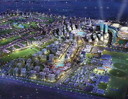
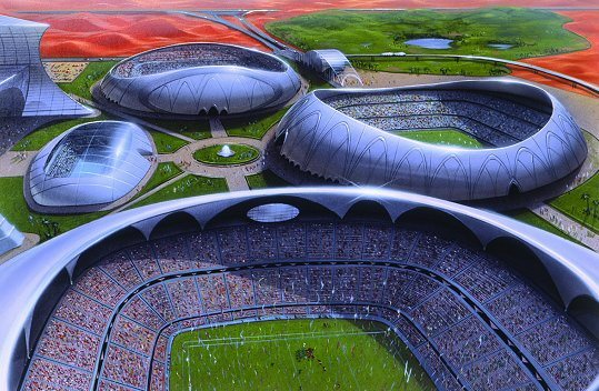
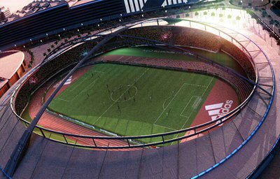
basketball and volleyball, capacity 10,000 spectators; and a dedicated hockey stadium, capacity 10,000 spectators.

  • Sports Academies - The Manchester United Soccer Schools, Butch Harmon School of Golf, David Lloyd (Leisure, Spa, and Tennis Academies), and the International Global Cricket Academy.

  • Training Facilities - Multi-sport training facilities including gymnasiums, Olympic pools, and a state-of-the-art sports rehabilitation center.

  • Golf Course - 18-hole Ernie Els golf course being designed in association with Nicklaus Design.

  • Residences - Various residential communities and high-rise buildings offering spectacular views of the surrounding golf course, stadiums and canals.

  • Commercial - The biggest brands, franchises and contemporary icons from the business, hospitality, entertainment and sports training worlds will all be represented in Dubai Sports City.

The world's largest indoor ski resort is located in Dubai's desert. Over 6,000 tons of snow are manufactured here per day.

Dubai has the world's only seven-star hotel, the Burj Al-Arab, which also boasts the world's tallest atrium. Rooms run $2,000 to $16,000 per night but come with special touches like a 16 page "pillow menu." The hotel is usually booked solid months in advance.
Want to go snow skiing in the desert? No problem. The world's largest indoor ski resort is located in the world's second largest shopping mall.

A Developer with an Excellent Track Record

The Bridge's developer is The First Group, a British real estate company with more than 20 years in successful residential, commercial and resort development. The firm has specialized in overseas investment property in emerging markets including Cyprus, Hungary, Eastern Europe, Asia, the Far East and Spain.
The Bridge is actually The First Group's second development in Dubai Sports City. The first, The Diamond condo hotel (pictured right), was released about six months ago and is now sold out. Early purchasers have already seen more than 25% appreciation.
The First Group now has a permanent base in Dubai where it is concentrating on high-quality investment property in Dubai and the Northern Emirates.

Quality Features in Each Unit

The condo hotel units will be accessed via their own private VIP entrance. They'll have their own balconies. They'll be fully furnished with high-quality, modern furniture and finishes, floor-to-ceiling glass for panoramic views, and the latest electronics like plasma TV's.

The Bridge at Sports City will offer studios, one- and two-bedroom condo hotel units.
Owners of The Bridge will place their condo hotel unit in a managed rental program and share in the revenue it generates. They may also choose to use their unit up to 30 days per year.

Five-star Amenities

The Bridge will be a state-of-the-art designed building developed by The First Group, a UK company. It will have all the features and services that you'd expect from a five-star luxury development such as:
  • Full-service spa
  • Children's pool area
  • Temperature controlled rooftop "sky pool"
  • Fully-equipped health club and gym
  • Restaurants
  • Retail stores
  • Beautiful fixtures and fittings throughout
  • Wireless internet throughout
  • 24-hour concierge services
  • Valet parking

The Bridge at Dubai Sports City

The Bridge will be an eye-catching five-star, world-class condo hotel. At 28 stories tall, it will offer stunning views of Dubai Sports City, especially its lovely canals and its immense main stadium (you'll have a bird's eye view of all the action). More on Dubai Sports City in a minute.
The Bridge will be a mix of condo hotel units, luxury residential apartments, and flexible commercial units. It will comprise two back-to-back curved buildings joined by a central shaft and finished in shimmering blue tones. Inside, the lobby and main reception area will be clad in granite and marble, with common areas on upper floors featuring beautiful, high-quality finishes.

Friday, November 4, 2011

salery range or architects


architecture picture


Modern Architecture

  1.  Modern architecture is a design located in the buildings that have simple type with out any ornamental constructions to them. This design of architecture very first arrived up close to 1900. By 1940 modern architecture was determined as an global style and became the dominant way to build for many a long time in the twentieth century. Modern day architects apply scientific and analytical techniques to design and style. 
Numerous historians relate the origins of this design of architecture to the social and political revolution of the time though others see contemporary architecture as primarily pushed by technological and engineering developments. The availability of new supplies this sort of as iron steel concrete and glass introduced about new developing techniques as portion of the industrial revolution. Some regard contemporary architecture as a reaction towards ancient building design. Previously mentioned all it is widely accepted as a issue of flavor.
For the international type the most frequently employed supplies are glass for the facade metal for exterior support and concrete for the floors and inside supports. The floor plans are practical and logical. But several people are not fond of the modern design. Theylocate its stark uncompromisingly rectangular geometrical designs fairly inhumane. They think this universal design is sterile elitist and lacks meaning


Making An Entrance

With the addition of a pair of sleek modern buildings, the western end of Chicago’s Wicker Park neighborhood now sports a contemporary gateway of sorts. And though the two buildings appear to be twins, there are some slight differences.
Containing only two-bedroom units, the building on the south side of the street—at 2157 West Division Street—is slightly narrower; its wider northern counterpart, at 2154 West Division, features three-bedroom condos and condos with two bedrooms and a media room. Mark Peters of Studio Dwell Architects designed both buildings; Ranquist Development built the structures on empty land once owned by Resurrection Health Care, which has a hospital next door.
civiltechknow@gmail.com
The units’ interiors have ten-foot-high ceilings, Arclinea kitchens, and contemporary bathrooms; many condos have white oak flooring, and all of them have solid-core birch doors and horizontal cedar planking on some walls. Each building has six units; at press time, the two third-floor units remained for sale in both buildings. The 1,550-square-foot two-bedroom units are priced at $639,800; the larger (1,750 square feet) condos go for $729,800. Both buildings were scheduled to be ready for occupancy by late September.


comeOn civil engg....


Civil Engineering Building the Future

Civil engineers have one of the world's most important jobs: they build our quality of life. With creativity and technical skill, civil engineers plan, design, construct and operate the facilities essential to modern life, ranging from bridges and highway systems to water treatment plants and energy­efficient buildings. Civil engineers are problem solvers, meeting the challenges of pollution, traffic congestion, drinking water and energy needs, urban redevelopment and community planning.


There are seven major, interrelated branches of civil engineering:
Structural Engineering
Structural engineers face the challenge of designing structures that support their own weight and the loads they carry, and that resist extreme forces from wind, earthquakes, bombings, temperature and others. Bridges, buildings, amusement park rides and many other kinds of projects are included within this speciality. Structural engineers develop appropriate combinations of steel, concrete, timber, plastic and new exotic materials. They also plan and design, and visit project sites to make sure work is done properly.
Environmental Engineering
The skills of environmental engineers have become increasingly important as we protect our fragile resources. Environmental engineers translate physical, chemical and biological processes into systems to destroy toxic substances, remove pollutants from water, reduce non­hazardous solid waste volumes, eliminate contaminants from the air and develop groundwater supplies. Environmental engineers are called upon to resolve the problems of providing safe drinking water, cleaning up contaminated sites with hazardous materials, disposing of wastewater and managing solid wastes.
Geotechnical Engineering
Geotechnical engineering is required in all aspects of civil engineering because most projects are supported by the ground. A geotechnical engineer may develop projects below the ground, such as tunnels, foundations and offshore platforms. They analyse the properties of soil and rock that support and affect the behaviour of these structures. They evaluate potential settlements of buildings, the stability of slopes and fills, the seepage of ground water and the effects of earthquakes. They investigate rocks and soils at a project site and determine the best way to support a structure in the ground. They also take part in the design and construction of dams, embankments and retaining walls.
Water Resources Engineering
Water is essential to our lives, and water resources engineers deal with the physical control of water. They work with others to prevent floods, supply water for cities, industry and agriculture, to protect beaches or to manage and redirect rivers. They design, construct and maintain hydroelectric power facilities, canals, dams, pipelines, pumping stations, locks, seaport facilities or even waterslides.
Transportation Engineering
The quality of a community is directly related to the quality of its transportation system. Transportation engineers work to move people, goods and materials safely and efficiently. They find ways to meet our ever-increasing travel needs on land, air and sea. They design, construct and maintain all types of transportation facilities, including airports, highways, railroads, mass transit systems and ports. An important part of transportation engineering is upgrading our transportation capability by improving traffic control and mass transit systems, and by introducing high­speed trains, people movers and other intermodal transportation methods.
Construction Engineering
The construction phase of a project represents the first tangible result of a design. Using technical and management skills, construction engineers turn designs into reality ­ on time and within budget. They apply their knowledge of construction methods and equipment, along with the principles of financing, planning and managing, to turn the designs of other engineers into successful facilities.
Urban and Community Planning
Planners are concerned with the full development of a community. They analyse a variety of information to co-ordinate projects, such as projecting street patterns, identifying park and recreation areas, and determining areas for industrial and residential growth. They employ their technical and people skills to co-ordinate with other authorities to integrate freeways, airports and other related facilities.
Qualifications and Trends
More and more, those entering the civil engineering field must have skills in communication, computers, management and foreign languages, as well as advanced knowledge in a speciality within civil engineering. Students increasingly need to have knowledge of foreign languages or cultures, because many civil engineering mega projects are now overseas: Petronas Towers in Malaysia, the Channel Tunnel in Europe and the new Akashi Kaikyo Bridge in Japan, which is the longest suspension bridge in the world.
Engineers with geotechnical and environmental engineering expertise remain in strong demand because environmental concerns touch all infrastructure projects. Robotics and computer skills are also prized in civil engineering as automation and information technologies continue to evolve the civil engineering workplace. Today's engineers will see more specialisation, working in teams, globalisation, new materials and increased use of computer applications.
Today, engineers must continue their education long after their bachelor's degree. Whether through continuing education and professional development programs, many of which are offered through ASCE, or master's degree programs, students will need to increase their knowledge base to remain competitive. In addition, more and more employers are encouraging employees to earn master's degrees and become licensed professional engineers.
Future Demand and Salaries
The demand for civil engineers will remain strong. According to the U.S. Department of Labor, the number of U.S. civil engineering jobs will increase from the current 184,500 (1994 figure) to 218,700 by the year 2005. That growth rate is average for most job fields. The market for engineers in the U.S. is in infrastructure renewal, as so much of our infrastructure - from highways and bridges to water treatment systems and dams - are decaying and in need of repair. In 1998, the U.S. Congress passed a new transportation funding bill that increases spending by 40 percent to rebuild some 150,000 miles of roads. The new funding will create 1.4 million new jobs in the transportation construction industry, according to the American Road and Transportation Builders. Many engineering firms and state transportation departments are understaffed to handle all the work.

According to the most recent U.S. salary survey conducted by ASCE in 1995, entry-level civil engineers earn an average of $32,000; mid-career engineers earn $52,000-$58,000; and senior engineers average $73,000-$86,000.
Resources for Students
The American Society of Civil Engineers (ASCE), headquartered in Reston, Virginia, is a professional society for 123,000 civil engineers worldwide, with several programs to encourage and support civil engineering students. The Society publishes a booklet on civil engineering careers, and has active student chapters at more than 225 colleges and universities throughout the U.S. For more information on civil engineering careers or college engineering programs, contact the Educational Activities Division of ASCE at 703/295-6000.
Author

James E. Davis
Executive Director and CEO
American Society of Civil Engineers

Friday, January 21, 2011

I Feel The Earth Move Under My Feet


Yeah, it's been awhile since my last posting. I've been spending huge amounts of time, planning and developing my new business.

But it all takes time. Branding identity (see new logo above). Refining the niches that will be my target clients. Developing value promises. Brainstorming products. Creating content. Determining revenue streams and cost structures. Envisioning the web presence and acquiring necessary domain names. Looking into joint ventures and cross-promotions.

"So," you say, "this must be an absolutely awful time to start-up a new company. Correct?"

Nope. On the contrary, this might be the best time in a long time to start a new operation. The happenings of the last six months have been like an earthquake, moving the tectonic plates, as it were, creating major new rifts. The walls are tumbling down, and so the barriers to entry into the marketplace are falling, too.

So I'm in a very confident and assured place, right now. I'm no fool -- things won't be peachy keen for awhile yet.

But I see clear opportunities that transcend current market conditions. Stay tuned. You'll be seeing significant changes here in the weeks to come, and I'll be offering services and products that provide true value. And if you just can't wait that long to find out what's up, give me a call.

Saturday, January 15, 2011

Global Positioning System - Importance in Civil Enigineering

Object:
This System provides us with accurate horizontal and vertical measurements and gives us the position of observer in terms of Latitude and Longitude.

Advantages:

  1. This system is fast replacing with conventional methods of surveying like Triangulation, Traversing etc.
  2. It no longer requires the inter-visibility of station points. The conventional techniques are still required for detail surveying.
  3. The horizontal and vertical control can easily be established with the help of GPS.


Instruments:
This system basically requires the receiver which is setup at the point of observation. The second part of the equipment is no of satellites which are 18, launched into 6 different orbits.Each orbit have three satellites with 120º interval. The height of satellite is about 20,000 km with orbiting vilocity of 11hr 58min.
The GPS is controlled from an airforce base in Callifornia (USA).

GPS - Surveying

Procedure:
The GPS position is achieved by the precise measurement of the distance between the satellite and the receiver at an instant of time.
For a three dimensional measurements three or four satellites will be needed depending upon the quality of receiving equipment. It requires highely accurate clocks both in the transmitter and in the receiver to measure the precise distance between them.

Applications:

  1. This system gives us the accurate geographic position required for land surveying.
  2. It is used for navigation purposes in Aircraft,Ships,Submarines etc.
  3. It is now exceedingly used to locate the enemy targets and subsequently hitting them by GPS information guided missiles.
  4. For public use simpler version are available for locating the vehicles, the individuals and the parties, in hicking and mountaineering expeditions and other number of applications.

What a Surveyor Does

A surveyor travels to the property and analyzes it with respect to it's surroundings. Most of the time, he will use equipment to measure the distances of various objects on the property, research the county courthouse for legal descriptions and recorded drawings of the property, interprets the data, and draws a sketch of the property on a sheet of paper. While geometry and trigonometry are important knowledge for a surveyor, he also must be fluent in the local laws and court rulings concerning property transactions and rights.
The survey that the surveyor produces, while highly accurate, is considered as an approximation of the property's boundary and it's topography in the court system. A surveyor does not grant land, only the courts can grant land to an individual, but the surveyor's knowledge of the property is used by the courts in determining the property's boundary.

The Art of Surveying

According to Wilhelm Schmidt in an article printed in Professional Surveying Magazine, surveying is an art because it is a process of making something while using instruments. The surveyor's instruments are his mathematical knowledge of geometry and trigonometry along with the electronic measuring devices, chains, and compasses to produce a survey of the property. A surveyor learns the mathematical principles under the sterilized, textbook world of a university and then apply his knowledge to the real world where nothing corresponds to the standard "rules" learned in school.
Schmidt believes that the artistic part of surveying lies in the surveyor's decisions in choosing the equipment, mathematical principles, past surveys, and legal descriptions to achieve a high degree of accuracy while making sense out the chaos of life. A surveyor must deal with monuments located in the wrong place or destroyed. He must make decisions based on unreadable plats or recorded legal descriptions with typographical or mathematical errors while basing his survey on a fence line that may or may not of moved since the last survey of the property in the early 1900's. Surveying is very much an art based on the interpretation of historical fact.

Global Positioning Satellites (GPS):


                       GPS (Global Positioning Satellites) is quickly becoming one of the more frequently used surveying instruments today. With GPS, a surveyor can cover more ground in less time than more conventional methods. However, there are risks associated with GPS if not used correctly.
Gamba and Associates, like most surveyors who use global positioning satellites, rely primarily on differential GPS for our GPS surveying needs. Differential GPS uses a base receiver at a known and previously checked control point, often a government monument, and a roaming receiver or rover. The base receiver and rover record concurrent satellite data which is used to determine the rover's position relative to the base. The base and the rover are connected via a radio modem allowing instant access to location information at the rover.
GPS accuracy is dependent on numerous factors including tree canopy, number of satellites available to the receiver, and ionosphere and sun spot activity, but the average accuracy of differential GPS is 1 cm (0.394 inches) plus 1 ppm for horizontal measurements and 2 cm (0.787 inches) plus 1 ppm for vertical measurements. It should be noted that these accuracies are only achieved with survey level differential GPS units and not a common hand held unit purchased at the store. The documentation accompanying the hand held unit should address the accuracies of that particular unit.
          As mentioned above, GPS surveying has to be used correctly and is sometimes limited in it's application. Since GPS surveying relies on the ability to use satellites, one must be able to "see" enough of the sky to collect data from a minimum of four satellites at the same time. Areas with dense overhead vegetation (i.e. trees) or with steep adjacent hillsides, all of which block the view of the sky, often are not suitable areas for GPS surveying and other techniques must be utilized.

Prydniprovs’ka State Academy of Civil Engineering and Architecture

Central & Eastern
European Directory On-Line

Prydniprovs’ka State Academy of
Civil Engineering and Architecture 


RectorProfessor Vladimir I. Bolshakov
Address24 a, Chernyshevsky Street, Dnepropetrovsk, 49600, Ukraine
Tel. No.+380 562 471688
Fax No.+380 562 471688
E-mail addressdik@pgasa.dp.ua
Name of contact personProf. Boris Dikarev
Vice-Rector of PSACEA
Programmes

  • Architecture


  • Ecology


  • "Automation and Computer Integrating Technologies


  • Engineering Mechanics


  • Construction


  • Economy


  • Management


  • Type of coursesFull-time and part-time
    Length of coursesBachelor of Arts - four years
    Bachelor of Science - four years
    Engineer of speciality - five years (one year after Bachelor Degree)
    Master of Arts - six years (two years after Bachelor Degree)
    Master of Science - six years (two years after Bachelor Degree)
    Date of commencement1 September
    Class size25 students
    AccommodationAvailable
    FeesOverseas students: 1,500 USD per year
    Financial assistanceAvailable for National students
    Admission requirementsThe Standard for admission to degree program at PSACEA is the successful completion of Secondary School Diploma The overall average must be at least 60 %. In addition applicants will be required to pass entrance examinations specified by the faculty.

    Admissions to the first year as well as advanced standing placement at the PSACEA of students who are neither Ukrainian Citizens nor permanent residents is carrying only on the contract base. Foreign students must obtain a Ukrainian Entry Visa and Student Authorisation from Ukrainian embassy or consulate outside of Ukraine. It is not possible to change from "visitor" to "student" status from within Ukraine. For getting Student Authorisation applicants must take an invitation for admission at the Academy.

    Applicants whose first language is not Ukrainian or Russian must take the preparatory course before enrolled on the first course of degree program. For French-speaking students training in French is available. They can enter the first course of degree program without certificate of preparatory graduation.
    Student profile• Ratio of national/ overseas students: 100/6
    • Ratio men/ women: 2,7/1,7
    • Age range: 17-25

    Tuesday, January 11, 2011

    STATUE

    World's top 10 most beautiful buildings

    1. Melbourne Recital Centre in Australia

    Melbourne Recital Centre, which opened to the public at the beginning of this year, won the National Award for Public Buildings at the 2009 Property Council of Australia Rider Levett Bucknall Awards for Innovation and Excellence.


    2. The Gherkin in London

    The Gherkin is located at the 30 St Mary Axe in London and was put into use in 2004. The 40-story building is 600 feet (90m) high.

    3. Tancici Dum in Prague

                                                   
              Tancici Dum (Dancing Building), completed in 1996, was designed by famous architect Frank Gehry. It looks like a dancing couple, and some people call it "drunkard building."

    4. Esplanade in Singapore

                    Esplanade, a leading artistic performance center in Singapore, is often called "The Durian" by locals for its unique dome
    .
    5. Oslo Opera House in NorwaY

                                                
                Oslo Opera House, which was put into use in 2008, is an amazing marble and granite vision that rises out of the fjord like a giant ice floe.

    6. The Ray and Maria Stata Center in U.S

    .
                          The Ray and Maria Stata Center, located at MIT in Cambridge, was also designed by Frank Gehry. It was put into use in 2004.

    7. The Seattle Central Library in U.S.


                          The Seattle Central Library is the flagship library of the Seattle Public Library system. It was designed by Dutch architect Rem Koolhaas.

    8. The Hearst Tower in U.S


    The Hearst Tower in New York was designed by British architect Norman Foster. (Photo: huanqiu.com)


    9. The City of Arts and Sciences in Spain

                                  
               The City of Arts and Sciences, developed by Santiago Calatrava, is a large-scale urban recreation center for culture and science.

    10. The New Museum of Contemporary Art in U.S.


                                  The New Museum of Contemporary Art, founded in 1977 by Marcia Tucker, is the only museum in New York City exclusively devoted to presenting contemporary art.