Friday, January 21, 2011

I Feel The Earth Move Under My Feet


Yeah, it's been awhile since my last posting. I've been spending huge amounts of time, planning and developing my new business.

But it all takes time. Branding identity (see new logo above). Refining the niches that will be my target clients. Developing value promises. Brainstorming products. Creating content. Determining revenue streams and cost structures. Envisioning the web presence and acquiring necessary domain names. Looking into joint ventures and cross-promotions.

"So," you say, "this must be an absolutely awful time to start-up a new company. Correct?"

Nope. On the contrary, this might be the best time in a long time to start a new operation. The happenings of the last six months have been like an earthquake, moving the tectonic plates, as it were, creating major new rifts. The walls are tumbling down, and so the barriers to entry into the marketplace are falling, too.

So I'm in a very confident and assured place, right now. I'm no fool -- things won't be peachy keen for awhile yet.

But I see clear opportunities that transcend current market conditions. Stay tuned. You'll be seeing significant changes here in the weeks to come, and I'll be offering services and products that provide true value. And if you just can't wait that long to find out what's up, give me a call.

Saturday, January 15, 2011

Global Positioning System - Importance in Civil Enigineering

Object:
This System provides us with accurate horizontal and vertical measurements and gives us the position of observer in terms of Latitude and Longitude.

Advantages:

  1. This system is fast replacing with conventional methods of surveying like Triangulation, Traversing etc.
  2. It no longer requires the inter-visibility of station points. The conventional techniques are still required for detail surveying.
  3. The horizontal and vertical control can easily be established with the help of GPS.


Instruments:
This system basically requires the receiver which is setup at the point of observation. The second part of the equipment is no of satellites which are 18, launched into 6 different orbits.Each orbit have three satellites with 120ยบ interval. The height of satellite is about 20,000 km with orbiting vilocity of 11hr 58min.
The GPS is controlled from an airforce base in Callifornia (USA).

GPS - Surveying

Procedure:
The GPS position is achieved by the precise measurement of the distance between the satellite and the receiver at an instant of time.
For a three dimensional measurements three or four satellites will be needed depending upon the quality of receiving equipment. It requires highely accurate clocks both in the transmitter and in the receiver to measure the precise distance between them.

Applications:

  1. This system gives us the accurate geographic position required for land surveying.
  2. It is used for navigation purposes in Aircraft,Ships,Submarines etc.
  3. It is now exceedingly used to locate the enemy targets and subsequently hitting them by GPS information guided missiles.
  4. For public use simpler version are available for locating the vehicles, the individuals and the parties, in hicking and mountaineering expeditions and other number of applications.

What a Surveyor Does

A surveyor travels to the property and analyzes it with respect to it's surroundings. Most of the time, he will use equipment to measure the distances of various objects on the property, research the county courthouse for legal descriptions and recorded drawings of the property, interprets the data, and draws a sketch of the property on a sheet of paper. While geometry and trigonometry are important knowledge for a surveyor, he also must be fluent in the local laws and court rulings concerning property transactions and rights.
The survey that the surveyor produces, while highly accurate, is considered as an approximation of the property's boundary and it's topography in the court system. A surveyor does not grant land, only the courts can grant land to an individual, but the surveyor's knowledge of the property is used by the courts in determining the property's boundary.

The Art of Surveying

According to Wilhelm Schmidt in an article printed in Professional Surveying Magazine, surveying is an art because it is a process of making something while using instruments. The surveyor's instruments are his mathematical knowledge of geometry and trigonometry along with the electronic measuring devices, chains, and compasses to produce a survey of the property. A surveyor learns the mathematical principles under the sterilized, textbook world of a university and then apply his knowledge to the real world where nothing corresponds to the standard "rules" learned in school.
Schmidt believes that the artistic part of surveying lies in the surveyor's decisions in choosing the equipment, mathematical principles, past surveys, and legal descriptions to achieve a high degree of accuracy while making sense out the chaos of life. A surveyor must deal with monuments located in the wrong place or destroyed. He must make decisions based on unreadable plats or recorded legal descriptions with typographical or mathematical errors while basing his survey on a fence line that may or may not of moved since the last survey of the property in the early 1900's. Surveying is very much an art based on the interpretation of historical fact.

Global Positioning Satellites (GPS):


                       GPS (Global Positioning Satellites) is quickly becoming one of the more frequently used surveying instruments today. With GPS, a surveyor can cover more ground in less time than more conventional methods. However, there are risks associated with GPS if not used correctly.
Gamba and Associates, like most surveyors who use global positioning satellites, rely primarily on differential GPS for our GPS surveying needs. Differential GPS uses a base receiver at a known and previously checked control point, often a government monument, and a roaming receiver or rover. The base receiver and rover record concurrent satellite data which is used to determine the rover's position relative to the base. The base and the rover are connected via a radio modem allowing instant access to location information at the rover.
GPS accuracy is dependent on numerous factors including tree canopy, number of satellites available to the receiver, and ionosphere and sun spot activity, but the average accuracy of differential GPS is 1 cm (0.394 inches) plus 1 ppm for horizontal measurements and 2 cm (0.787 inches) plus 1 ppm for vertical measurements. It should be noted that these accuracies are only achieved with survey level differential GPS units and not a common hand held unit purchased at the store. The documentation accompanying the hand held unit should address the accuracies of that particular unit.
          As mentioned above, GPS surveying has to be used correctly and is sometimes limited in it's application. Since GPS surveying relies on the ability to use satellites, one must be able to "see" enough of the sky to collect data from a minimum of four satellites at the same time. Areas with dense overhead vegetation (i.e. trees) or with steep adjacent hillsides, all of which block the view of the sky, often are not suitable areas for GPS surveying and other techniques must be utilized.

Prydniprovs’ka State Academy of Civil Engineering and Architecture

Central & Eastern
European Directory On-Line

Prydniprovs’ka State Academy of
Civil Engineering and Architecture 


RectorProfessor Vladimir I. Bolshakov
Address24 a, Chernyshevsky Street, Dnepropetrovsk, 49600, Ukraine
Tel. No.+380 562 471688
Fax No.+380 562 471688
E-mail addressdik@pgasa.dp.ua
Name of contact personProf. Boris Dikarev
Vice-Rector of PSACEA
Programmes

  • Architecture


  • Ecology


  • "Automation and Computer Integrating Technologies


  • Engineering Mechanics


  • Construction


  • Economy


  • Management


  • Type of coursesFull-time and part-time
    Length of coursesBachelor of Arts - four years
    Bachelor of Science - four years
    Engineer of speciality - five years (one year after Bachelor Degree)
    Master of Arts - six years (two years after Bachelor Degree)
    Master of Science - six years (two years after Bachelor Degree)
    Date of commencement1 September
    Class size25 students
    AccommodationAvailable
    FeesOverseas students: 1,500 USD per year
    Financial assistanceAvailable for National students
    Admission requirementsThe Standard for admission to degree program at PSACEA is the successful completion of Secondary School Diploma The overall average must be at least 60 %. In addition applicants will be required to pass entrance examinations specified by the faculty.

    Admissions to the first year as well as advanced standing placement at the PSACEA of students who are neither Ukrainian Citizens nor permanent residents is carrying only on the contract base. Foreign students must obtain a Ukrainian Entry Visa and Student Authorisation from Ukrainian embassy or consulate outside of Ukraine. It is not possible to change from "visitor" to "student" status from within Ukraine. For getting Student Authorisation applicants must take an invitation for admission at the Academy.

    Applicants whose first language is not Ukrainian or Russian must take the preparatory course before enrolled on the first course of degree program. For French-speaking students training in French is available. They can enter the first course of degree program without certificate of preparatory graduation.
    Student profile• Ratio of national/ overseas students: 100/6
    • Ratio men/ women: 2,7/1,7
    • Age range: 17-25

    Tuesday, January 11, 2011

    STATUE

    World's top 10 most beautiful buildings

    1. Melbourne Recital Centre in Australia

    Melbourne Recital Centre, which opened to the public at the beginning of this year, won the National Award for Public Buildings at the 2009 Property Council of Australia Rider Levett Bucknall Awards for Innovation and Excellence.


    2. The Gherkin in London

    The Gherkin is located at the 30 St Mary Axe in London and was put into use in 2004. The 40-story building is 600 feet (90m) high.

    3. Tancici Dum in Prague

                                                   
              Tancici Dum (Dancing Building), completed in 1996, was designed by famous architect Frank Gehry. It looks like a dancing couple, and some people call it "drunkard building."

    4. Esplanade in Singapore

                    Esplanade, a leading artistic performance center in Singapore, is often called "The Durian" by locals for its unique dome
    .
    5. Oslo Opera House in NorwaY

                                                
                Oslo Opera House, which was put into use in 2008, is an amazing marble and granite vision that rises out of the fjord like a giant ice floe.

    6. The Ray and Maria Stata Center in U.S

    .
                          The Ray and Maria Stata Center, located at MIT in Cambridge, was also designed by Frank Gehry. It was put into use in 2004.

    7. The Seattle Central Library in U.S.


                          The Seattle Central Library is the flagship library of the Seattle Public Library system. It was designed by Dutch architect Rem Koolhaas.

    8. The Hearst Tower in U.S


    The Hearst Tower in New York was designed by British architect Norman Foster. (Photo: huanqiu.com)


    9. The City of Arts and Sciences in Spain

                                  
               The City of Arts and Sciences, developed by Santiago Calatrava, is a large-scale urban recreation center for culture and science.

    10. The New Museum of Contemporary Art in U.S.


                                  The New Museum of Contemporary Art, founded in 1977 by Marcia Tucker, is the only museum in New York City exclusively devoted to presenting contemporary art.
                                   

    Samuel Beckett Bridge – Door to Dublin

    It seems as if Dublin were a magnet for the world’s leading names in terms of architecture. Of course this is an honor for the city and a treat for her residents and visitors. Even if architecture and structural or civil engineering are not what makes your heart skip a beat, the latest design by world-renowned architect Santiago Calatrava will definitely bring a smile to your face, even if it’s lashing (raining hard and sideways) on you as you make use of his work.
    What I am talking about is the Samuel Becket Bridge, which was introduced into the Dublin cityscape in May of 2009 and finally inaugurated and opened in December 2009 to pedestrians, motorists, and cyclists. The four-lane structure is intended to become Dublin’s Eiffel Tower. The plus? There are no lines to wait in or admission to pay; you may also use it any time you want!
    In keeping with the iconic vision, the bridge is shaped like a harp (Ireland’s symbol), but laying on its side, the bridge is ingenious in its form and operation as it opens at a 90ยบ angle as if it were an actual door to allow for large ships passage into and out of Dublin.
    I am not sure if something like this exists anywhere else in the world, but I cannot hide my awe and amazement at such a structurally beautiful and innovative piece.

    TITAN Megashore -The world's leading falsework system

    • Fast and versatile
    • Lightweight, yet exceptionally strong
    The TITAN support system is recognised as the leading product
    in its field by many professionals in
    the construction and civil engineering industries.
    Comprising two main components; legs and frames, together with a comprehensive range of accessories, the TITAN support system offers one
    of the quickest, most effective and versatile means of providing rapid support and access solutions in an enormous variety of situations. The system can be used in both ‘flying table' and erect and dismantle applications and is ideal for multi-storey structures, water reservoirs and soffit situations where mobility and ease of handling are required.
    With the majority of components being manufactured from high grade aluminium to patented designs, the TITAN support system possesses an exceptionally high strength to weight ratio which facilitates rapid erection, whilst its excellent corrosion resistance and robust build quality assure long term durability.
    The TITAN support system is designed to reduce labour costs, increase site efficiency, improve safety and meet the demands of today's construction and civil engineering techniques.
    Project Manager (PM)

    Location : Technopark
    For a leading Group for its IT infrastructure Project.


    BE Civil Engineer with exposure of developing  world class infrastructure facility especially for IT/IT parks would be preferred.


    PM would be lead in building and developing infrastructure as per IT Market requirements from scratch to finish.

    Relevant and interested applicant can send cv at
                  

    Coteau-du-Lac National Historic Site of Canada

    Why Build a Canal at Coteau-du-Lac?

    Construction of the Coteau-du-Lac lock canal
    Y. Larochelle, 1987, Parks Canada


     The American War of Independence (1775- 1783) revealed up a number of serious flaws in the British defence system. The western frontier of the colony was protected by the military outposts on the Great Lakes. However, these outposts were all the more vulnerable for being difficult to reach. Troop and merchandise transport via the River was seriously slowed by the rapids located upstream from Montrรฉal. In particular, the rapids at Coteau-du-Lac were the most difficult to get past. Skirting the rapids by going inland prolonged supply times. To solve this problem, Governor Haldimand ordered for a canal to be dug at Coteau-du-Lac.                      

    Captain William Twiss, a top ranking engineer who enjoyed notoriety both in Canada and in Great Britain, was the commander of the British army Royal Engineers. It was Captain Twiss who was the true instigator of the Coteau-du-Lac canal. Twiss proposed building a fortified canal as a means to accelerate shipment of military supplies westward.


    Panama Canal Construction


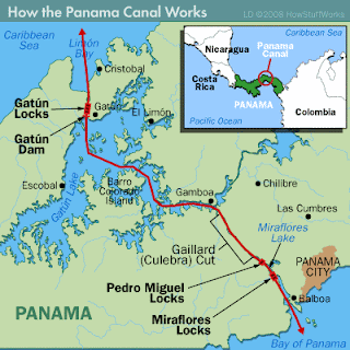
    With the lock-type plan in place for the Panama Canal, the United States needed an expert to execute it. Lt. Col. George Washington Goethals, an army engineer with lock expertise, became the new chief engineer. He divvied up the work into thirds: The Atlantic Division would work from Limรณn Bay to Gatรบn; the Central Division would run from Gatรบn to Pedro Miguel (and tackle the most challenging part of the project: the Gaillard (Culebra) Cut); and the Pacific Division would work from Pedro Miguel to the Panama Bay's deep waters.
    The U.S. made good use of the Panamanian railroad that ran near the work, and the crews employed steam shovels, rock drills and dynamite to increase the efficiency of excavation. The work at the Gaillard (Culebra) Cut through the Continental Divide would have been impossible without such technology; men moved 96 million cubic yards (73 million cubic meters) of earth and rock and coped with huge dirt slides [source: Britannica]. Extreme heat and grisly accidents in the Cut gave it the name "Hell's Gorge."
    On Jan. 7, 1914, the crane Alexander La Valley made the first canal transit. The canal didn't open officially, however, for another eight months. Celebrations to mark the event were scaled back as news reached Panama of Germany's declaration of war on France, the effective start of World War I
                  
    Goethals' three-part division can be used to understand the canal as it is today. Ships approaching from the Atlantic first pass through the Gatรบn Locks -- a series of three lock sets that lift vessels 85 feet (26 m) to Gatรบn Lake. Once there, ships wind through the lake's channel for about 23 miles (37 km) before entering the Gaillard (Culebra) Cut. After about 8 miles (13 km) spent crossing through the Cut, ships reach the Pedro Miguel Locks. These locks lower ships 30 feet (9 m) to the Miraflores Lake, where they pass through a mile-long (2 km) channel. Ships then approach the two-stepped Miraflores Locks that return them to sea level. A 7-mile (11-km) passage takes them out to the Pacific. From deep water to deep water, the canal is 50 miles (80 km) long.
    Each of the locks is built in pairs to allow for two-way traffic. With a total transit time of eight to 10 hours, it just wouldn't make sense to run a one-way street [source: Panama Canal Authority]. To raise a ship, water is released from a lake (Gatรบn, Alajuela or Miraflores) or from a higher lock through valves that open on the upper end of the lock. To lower a ship, water drains to a lower lock or to the ocean through valves that open at the lower end of the lock. The locks are powered by electricity.
    Because so much hinges on the locks' integrity, safety precautions prevent large ships from sailing through on their own steam. An out-of-control large ship could plunge through a lock. Large craft are instead escorted by electric towing locomotives.

    Panama Canal


    The Panama Canal is undoubtedly one of the most complex, costly, and difficult engineering projects ever undertaken. As early as the 1550s there was talk of creating such a canal to create a vital waterway for speedier trade between the Americas. However, it wasn’t until over three centuries later that a serious attempt was made to build it. An initial effort by the French in the 1880s was given up after over 20,000 workers lost their lives to disaster and disease. Under subsequent American leadership systems were devised to transport soil away by rail and properly house workers for safety and health purposes though thousands of Americans also lost their lives before the canal was completed in the early 1900s.

    Eiffel Tower


    The Eiffel Tower is one of the most known and beloved monumental structures of the world, yet it was never intended to be. Designed for a world’s fair in the late 1800s the tower was intended to be a demonstration of modern engineering, not an object of lasting beauty, and was supposed to be deconstructed following the event. Amazingly, just 300 were needed to assemble 18,000 parts on site with 2.5 million rivets – and only one person perished in the construction process. Parisians at the time were shocked, dismayed and outraged at this bare metal structure towering the sky – a structure that has since become the primary symbol of Par

    Golden Gate Bridge

     The Golden Gate Bridge had, at the time of its creation, the longest span of any suspension bridge in the world. With estimates at over 100 million dollars a bridge was deemed unfeasible in this location for many years before one daring engineer promised it could be done for 17 million. One of the engineers of the Tacoma Narrows Bridge (a bridge infamous for its collapse) worked on the project – fortunately he did a better job with the Golden Gate. In the end, the construction came in just barely under budget and only 11 workers died during the creation of this massive and innovative bridge. As with the Eiffel Tower and Paris, the Golden Gate Bridge was widely considered ugly at the time but is now a universal symbol of San Francisco.

    e Zuiderzee Works

    Zuiderzee Works are an amazing feat of modern engineering constructed to protect The Netherlands from flooding as well as to create over a half million acres of usable farmland. Plans for the construction of this project date back to the 1700s but it wasn’t until a severe flood in the early 1900s that these plans were set in motion. Once the area was dammed off work began on pumping water out of certain areas to create usable land. One of these areas was even created during World War II and was used by the resistance as a hiding place. All in all an estimated 200 million square feet of sand was used and over 4,000 workers were employed daily in the construction of this immense water-retention system that at parts measures up to 300 feet thick at the lesurrounding water and resists tremendous water pressure

    The Channel Tunnel

    The Channel Tunnel (aka The Chunnel) is a relatively recent work of engineering genius. Completed in 1994, the Chunnel was (amazingly) first envisioned nearly 200 years prior as a means for horse-drawn carriages to cross between France and England. Even though it was built with modern safety standards the tunnel still cost the lives of 10 workers – only one fewer than the Golden Gate Bridge generations prior. The tunnel was bored with a dozen drilling machines and sits on average nearly 150 feet below the water above. A ‘pilot’ service hole was drilled to test soil conditions before secondary drills could completely carved out spaces.

    Saturday, January 8, 2011

    Small Residential Architecture Design: Summerwood Prefab Studios

    We formulate builds designs, from Toronto-based Summerwood, which can succulent resembling as well as bullwork body, for halfway a decennium. Settling in Town, River, this 12ft. As a family flat, work or flophouse ball-breaker stint – Rein out some of property and build myth for more than 260, 000 readers throughout that...

    Beautiful Small House Architecture in Punta del Este

    The small house architecture is situated in a small hill and boasts a breath taking 180 degree panoramic view of the ocean all the way from the Punta del Este peninsula to Punta de Piedras. The small house architecture with a unique natural garden design and a 250 sq m house.The small house architecture has a features are 4 bedrooms of which two of them are suits, reception toilette, a fully equipped kitchen, Quincho and barbecue, swimming pool and maid room with complete bathroom.

    Modern Small House Plan by Falconer + Jones and Andrew Brown

    This modern small house plan named Lugton Brae House comes from Edinburgh-based Falconer + Jones in collaboration with Andrew Brown architects. This is a small family home plan to be built in the garden to the rear of the existing house. The project is a proposal for a linear plan single storey [...]

    Small Hybrid House Architecture by HyBrid Architecture

    To break down the massing of the two buildings to address the small scale of the adjacent neighborhood, the two structures were sited to allow Southern solar access and view corridors to all four units. we chose to respect the small single-family home neighboring the property by creating a detached single family homes at the rear alley.This house has similar characteristics including horizontal Paulownia open joint rain screen enclosure assembly which mim-micks the lap-siding of the existing homes in neighborhood.

    temple construction-File:Vastu-purusha-mandala

    Architecture Program

    Our Mission

    The Architecture Technology Program at Lansing Community College is dedicated to providing all students interested in the study of architecture with the academic means to achieve their individual goals.  To achieve this mission, the program will structure all curricula, courses, events and activities as part of an instructive learning environment, designed and implemented by field trained professionals, using the latest techniques and technology available.  The Architecture Technology Program will continually seek direction and guidance from a board of advisors who represent a diverse cross section of practicing professionals throughout the field of architecture.


    The Study of Architecture at LCC

    The Architecture Technology Program at Lansing Community College offers students a comprehensive, two-year Associate of Applied Science Degree in the study of architecture or the opportunity to take just one or two courses for your individual interest or to upgrade a specific skill. Our two-year degrees and the one-year certificate offered in Architecture Technology are intended to prepare students to work in one of the many areas of the architecture profession. All (ARCH) courses are designed and taught by practicing professionals using the latest technology and teaching techniques.
    In addition to the regular semester length courses offered each Fall, Spring, and Summer, the program offers a wide variety of additional activities and events such as lectures and field trips for the benefit of the students to make their educational experience at Lansing Community College as complete as possible.  In addition to more than 30 ARCH courses that students may choose from to structure their degrees, Lansing Community College also offers hundreds of additional courses in related fields such as Interior Design, Kitchen and Bath Design, Landscape Architecture, Art and Humanities, Building Technology, and Civil Construction.

    Landscape Architecture Program

    Landscape Your Future

    Landscape architects create attractive and functional designs to meet the needs of residential and commercial property owners. This field combines art and science and deals with the complex relationships between man-made features and natural environments.  The Landscape Architecture Program can provide you with the academic and professional training you need to design a niche for yourself in the industry.

    Landscape architect technicians and designers are employed by engineering firms, parks and recreation departments, landscape contractors, design and build firms, nurseries and garden centers, botanical gardens, and grounds management firms.  Landscape architect technicians work with architects, city planners, civil engineers, hydrologists, surveyors, contractors, and environmental engineers. The national employment projection for landscape architects and related fields is expected to increase faster than average through 2016.

    Interior Design Program

    Consider pursuing a career as an interior designer.  Increasingly, business owners and homeowners are placing more emphasis on the form and function of places where they conduct business and live. As this shift in attention occurs, the skills of the interior design professional as a spatial planner become even more pertinent. Whether employed with a wholesale or retail showroom, a design firm, a home center chain or a facilities planning division for governmental or commercial entities, building a career as an interior designer holds a variety of possibilities for persons with the right skills, persistence, and a penchant for creativity.  Form.  Color. Function. Aesthetic appeal.
               Being able to convincingly communicate visual ideas through written proposals as well as via oral presentations is another common characteristic of the interior designer. These professionals are expected to be well-versed in specialized areas as energy efficiency, interiors for the physically challenged and the elderly all while taking into consideration environmental safety. A working knowledge of computer aided-design is also a requisite skill.
               

    Construction and Maintenance Program

    The Residential Building Program is now offering BLDT 170 which fulfills the State of Michigan 60-hour requirement to apply for a Residential Builder or Maintenance & Alteration Contractor License.  Call 517-483-5338 for more information.

    Residential Building Program

    If you're an individual who likes the challenge of building and renovation projects or has always taken a certain degree of pride in your woodworking or carpentry ability, maybe now is the time to channel your interests into a career. There's no better place to begin than with the academic and training experience you can receive through the Residential Building Program at Lansing Community College. In it, you will learn the essentials needed to construct single-family and multiple-family housing complexes such as apartment and condominiums. Generally, program graduates begin on a framing crew and move up to framing crew leader. The next step would be to become a superintendent or construction manager. Many go on to own a building business while others get involved in the supply side of the construction industry.
                        

    Civil Technology Program

    As the population of the country's cities and towns grows, the need increases for additional highways, buildings, tunnels, bridges and water supply and sewage systems. The individuals who help build these systems are civil engineers, a specialized group of professionals called on to be involved with the design and construction of the infrastructure of the nation. More of these professionals are needed now and into the future.
    Civil engineering technicians work for construction, engineering and architectural firms and are often employed by state, city and federal government agencies, cartography agencies and various private petroleum and mining operations. Employment of civil engineering technicians is expected to increase 10 to 20 percent now through 2010, with even greater employment prospects projected in Michigan.  Visit career facts for more information on careers in civil technology.


    Environmental, Design & Building Technologies

    f the prospect of employment in this career field interests you, are you ready to compete for job openings? If not, you can get the training you need through the Civil Technology Program at Lansing Community College. Our program is rigorous, high quality and designed to provide you with instruction based on the practical application of the principles of civil technology covering topics as civil drafting, surveying, construction materials, traffic technology, applied physics, math and more. Our faculty members are seasoned professionals who are active in the field, bringing real-world relevance to your classroom experience. In addition to core courses and general education requirements in this degree program, students interested in obtaining practical field experience may apply for a six month co-op offered in conjunction with the Michigan Department of Transportation.  Both the Civil Technology Associate in Applied Science degree and the Surveying and Materials Technician Certificate of Completion are available. Courses are offered throughout the year. Many are available evenings as well as days to accommodate your schedule. Spring semester begins in January, summer semester begins in June and fall classes begin in August.
    We want you in our classroom next semester. If you need direction on how to begin at LCC, let us know what's on your mind and what you need to get started. We've got a place waiting for you in the classroom that can lead you to a great career start. For specific information about our Civil Technology Program,

    Geometry of Bridge Construction

     Types of bridges

                                      A. The beam or truss bridge is, in effect, a pair of girders supporting a deck spanning the gap between two piers. Such a beam has to withstand both compression in its upper parts and tension in its lower parts. Where it passes over supports, other forces come into play. A beam may be a hollow box girder or an open frame or truss.
    B. An arch bridge can be designed so that no part of it has to withstand tension. Concrete is well suited to arched bridge design. When reinforced concrete is used, a more elegant and sometimes less costly arch can be designed and most concrete arch bridges are reinforced.
    C. A suspension bridge consists, basically, of a deck suspended from cables slung between high towers. The cables of high tensile steel wire can support an immense weight. The towers are in compression and the deck, often consisting of a long slender truss (used as a hollow beam), is supported at frequent intervals along its length.
    D. A cantilever bridge is generally carried by two beams, each supported at one end. Unlike a simple beam supported at both ends, the cantilever must resist tension in its upper half and compression in its lower. 


    Energy Efficient Building Solutions

    GE is committed to offering a broad spectrum of energy efficient building solutions that benefit our customers. This portfolio of products includes high efficiency lighting and control systems, high efficiency motors and drives, and water reuse technology.
    In addition, GE Capital Real Estate has committed to evaluate and strategically improve the environmental footprint of GE Capital’s own global real estate portfolio by driving energy efficiency. Efficiency gains provide lower operating costs for existing tenants and GE Corporate Real Estate and a consequential reduction in environmental impact.
    An example is the use of ArdenACCESS, an Enterprise Building Automation Platform specifically for use in commercial real estate properties owned by GE Corporate Real Estate. The platform enables more efficient building operations through the use of advanced software tools, analytics and fault detection, reducing electricity usage, associated operating costs and CO2 emissions

    Friday, January 7, 2011

    surveying -emile brown


    District Engineering and On-Call Services - Freeland, Washington

    DCG is the District Engineer for the Freeland Water & Sewer District providing all engineering services for the District including comprehensive planning, capital improvements design, construction phase management, and on-call services. DCG completed the District’s Water System Plan update in 2004 and has been assisting with implementation of the plan. DCG  has provided ongoing on-call services for improvements projects including a booster pump station, distribution projects, a new reservoir and equipment building, chlorination equipment, telemetry upgrades, and well rehabilitation.

    The distribution projects have included a horizontal bore under SR 525, pipe bursting with HDPE pipe, and conventional PVC C900 and ductile iron pipe distribution, services, fire hydrants and appurtenances. DCG’s other on-call services include plan review, water and fire flow availability determination, rate study assistance, funding application assistance, wells and water rights acquisition, and attending District meetings. DCG also provides the Freeland Water and Sewer District with planning support for its on-going work to establish a sewer utility; finance study management, property acquisition, engineering studies, grant proposals, and grant management.